The Third Mainland Bridge
Most mornings, hundreds of thousands of Lagosians drive across the largest thing anyone has ever built in this city — and think about the traffic.
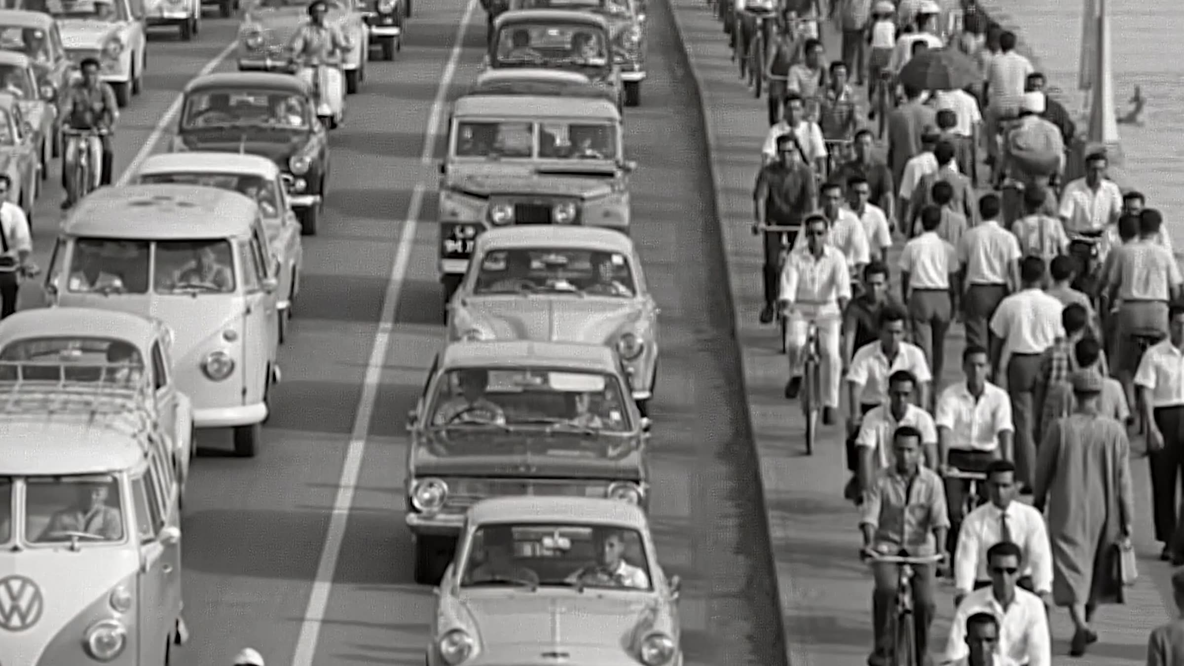
Archive footage, Lagos. Provenance and date being established — see the sources at the foot of this page.
What you see is the traffic.
It starts at Oworonshoki and ends on the island, and for most of the people on it that is the entire fact of the matter. A route. Somewhere you sit.
The crossing runs for , carrying . For six years it was . It was .
None of that is secret. It is written down, it is on the signs, it is in the engineering record. It simply isn't looked at.
There is a thing people say about this bridge — that from the moment you join it to the moment you leave it, there is no ground under your wheels.
It is a good line and it is not true. The engineering record describes built in the lagoon where the bridge meets the interchange at Ebute Metta. Part of the crossing stands on ground that was made for it.
We wanted the line. We're telling you why you won't hear it.
Underneath, it is standing on stilts.
The road you drive on is not resting on the lagoon. It is resting on columns, and those columns are resting on piles driven down through soft mud until they reach something that will hold.
The record describes , carrying . That is a lot of separate holes in the bottom of a lagoon.
That is the whole engineering problem of building anything large in Lagos. Not the distance. The ground.
We have a figure for how deep those piles go. We are not printing it, because is not something we can currently attribute to anyone.
Why here, and why then.
A bridge is an answer to a question somebody asked at a particular moment. The question here was what to do about a city that had outgrown two crossings — the Eko and the Carter — in a decade when traffic was rising faster than anything could be built. The film at the top of this page is : cars, bicycles and people, all using the same road at once.
It was . Phase one reached the interchange at Ebute Metta and stopped. Phase two, which carried it north to Oworonshoki, did not begin for another eight years.
Nothing in the engineering record explains the gap. That silence is the most interesting thing on the page.
The bridge took fourteen years to build, and for eight of them, nobody built anything. Work stopped in 1980 and did not restart until 1988.
The bridge is sometimes called Ibrahim Babangida Boulevard, and the same engineering record that gives us those dates also says the project was started and completed by his government.
Babangida took power in 1985. Phase one began in 1976. — both statements are in the same document, and they cannot both be right.
We are not going to quietly pick the half that reads better. We are going after the commissioning record.
Every bridge is a sentence somebody wrote about the future.
What grew because of it.
The bridge did what it was built to do, and then it did something else. Traffic moved. Then more people came, and the city that arrived to use it grew until the crossing was full again.
You can see Makoko from the deck. Most people do, for about four seconds, at speed. It is one of the most photographed settlements in West Africa and one of the least counted: . The absence of a number is worth saying out loud, because every figure you have ever read about it was invented by somebody.
There is now planned, on the same reasoning as this one.
Parts of the bridge were , after reports that the structure moved as traffic crossed it. Seven years of repairs on a road the city cannot function without.
Some observers put the vibration down to gridlock — the weight of a traffic jam sitting still on a structure designed for traffic that moves.
A piece that only admires this thing isn't worth publishing. What it cost, what it displaced, and what has been deferred goes in, or the rest of it isn't believed.
Who decided, and who wasn't asked.
This is the station the reporting has to earn. Not the engineering — the choosing. Who signed, who benefited, who was living on the route, and who found out when the machines arrived.
We know the client was . We do not yet know who was in the room.
You drive on this every day. But do you know what's underneath?
Forty seconds. The first film in the series, and the shortest version of everything below.
Made and paid for by Sponge Media. No sponsor on this film or this page.
Get the next one before anyone else.
One email when a new piece goes up. The working, the sources, and what we couldn't stand up. No more than that.
Subscribe on SubstackFree. Unsubscribe any time. We don't sell or share the list.
Where all of this came from
Every claim in the piece, with its source and its status. Nothing hidden in a footnote, including the things we haven't nailed down yet.
"At 11.8km long, it's the longest of three road bridges crossing Lagos Lagoon." ICE project record for the Third Mainland Bridge.
https://www.ice.org.uk/what-is-civil-engineering/infrastructure-projects/third-mainland-bridge-lagos ↗
Four lanes in each direction, overall structure width 33.1m including a 3.5m median separator.
https://www.ice.org.uk/what-is-civil-engineering/infrastructure-projects/third-mainland-bridge-lagos ↗
It held the title from opening until the 20.5km 6th October Bridge in Cairo was completed in 1996.
https://www.ice.org.uk/what-is-civil-engineering/infrastructure-projects/third-mainland-bridge-lagos ↗
Client listed as Ministry of Works and Transport, Lagos State Government. Construction engineers: Julius Berger.
https://www.ice.org.uk/what-is-civil-engineering/infrastructure-projects/third-mainland-bridge-lagos ↗
"Engineers constructed an artificial island in Lagos Lagoon at the point the bridge met the road interchange at Ebute Metta."
https://www.ice.org.uk/what-is-civil-engineering/infrastructure-projects/third-mainland-bridge-lagos ↗
"Engineers used two slender concrete shafts – or pillars – for each of the bridge's piers."
https://www.ice.org.uk/what-is-civil-engineering/infrastructure-projects/third-mainland-bridge-lagos ↗
"The project team constructed most of the bridge's spans at 45m, though some were up to 60m." A span is the distance between two piers.
https://www.ice.org.uk/what-is-civil-engineering/infrastructure-projects/third-mainland-bridge-lagos ↗
The film cites pile depths of 36–54 metres into the lagoon bed. The ICE record confirms the twin concrete shafts and the span lengths, but says nothing about pile depths. We have not found a citable source for that figure.
Black-and-white film of dense motor, bicycle and pedestrian traffic in Lagos. The vehicles are right-hand drive, which is the configuration Nigeria used before switching to left-hand drive on 2 April 1972. Split-screen VW Type 2 vans also point to the 1960s. That dates the film, but does not tell us who shot it or who owns it.
Phase one, Lagos Island to the interchange at Ebute Metta, ran 1976–1980. Phase two, north to Oworonshoki, ran 1988–1990.
https://www.ice.org.uk/what-is-civil-engineering/infrastructure-projects/third-mainland-bridge-lagos ↗
The same ICE record states the project was "started and completed by the government of General Ibrahim Babangida", and also that phase one ran from 1976 to 1980. Babangida took power in 1985. Both statements cannot be right.
https://www.ice.org.uk/what-is-civil-engineering/infrastructure-projects/third-mainland-bridge-lagos ↗
Estimates in circulation range from roughly 40,000 to over 300,000. The settlement has never been comprehensively enumerated, and figures are repeated without attribution.
A 38km fourth mainland bridge, two four-lane carriageways, reported at £2.3bn and expected to open in 2027.
https://www.ice.org.uk/what-is-civil-engineering/infrastructure-projects/third-mainland-bridge-lagos ↗
"Parts of the bridge were closed for repairs between 2006 and 2013 amid reports the structure was vibrating as traffic passed over it." Some observers attributed the vibration to gridlock loading the structure.
https://www.ice.org.uk/what-is-civil-engineering/infrastructure-projects/third-mainland-bridge-lagos ↗
Reporting
Edafe Daniel Eruotor
Editorial direction
Dayo Elegbe
Design and build
Sponge Media
Funding
Sponge Media. No sponsor.
Corrections and changes
- 26 Aug 2026 — First published.
- 26 Aug 2026 — Length, spans, pier construction, phasing and repair history sourced to the Institution of Civil Engineers.
- 26 Aug 2026 — The claim that no part of the crossing sits on ground is withdrawn. ICE records an artificial island at Ebute Metta.
- 26 Aug 2026 — Pile depths of 36–54m remain unsourced and are held out of the text.
- 26 Aug 2026 — Stock photography removed. Artwork on this page is drawn from the sourced record.